City Planning Models: Concepts and Applications for Urban Development
1. Introduction to City Planning Models
City planning models are crucial for understanding the complexities of urban development and managing growth in an efficient, sustainable manner. These models serve as representations of various elements within an urban environment, helping planners visualize current conditions, forecast future needs, and engage stakeholders effectively. For anyone involved in urban design or development, a comprehensive understanding of city planning models is indispensable, particularly as cities evolve and face contemporary challenges such as climate change, population growth, and technological advancements. The incorporation of city planning model provides a framework for assessing land use, transportation networks, and public amenities, ultimately improving the quality of life for residents.
1.1 Definition and Importance of City Planning Models
City planning models can be defined as systematic frameworks or representations used to assess, predict, and design the spatial distribution and interaction of various elements within an urban area. These can range from physical scale models, offering a tactile understanding of space, to sophisticated digital models that utilize algorithms to simulate and forecast urban behavior. The importance of these models lies in their ability to help policymakers, urban designers, and communities understand complex spatial relationships and how variables like traffic patterns, economic zones, and environmental factors interact within urban landscapes.
1.2 Historical Overview of Urban Planning Techniques
The discipline of urban planning has a rich historical tapestry that reflects socio-economic shifts and technological advancements over centuries. Early city planning models can be traced back to ancient civilizations, where city layout was determined by factors such as agriculture and defense. The Greeks and Romans innovated with grid patterns, while the Renaissance era saw a more aesthetic approach focusing on beauty and functionality. By the 20th century, the advent of industrialization brought about significant urban challenges, prompting the development of comprehensive planning practices that aimed at managing urban growth and ensuring sustainable development. Various schools of thought emerged during this time, such as the Garden City movement and Modernism, each proposing different principles for urban organization and design.
1.3 Relevance of City Planning Models in Today’s Context
Today, city planning models remain particularly relevant as urban areas worldwide grapple with unprecedented changes due to factors such as globalization, environmental shifts, and rapid technological evolution. As cities expand, planners must address issues like social equity, environmental sustainability, and economic resilience. Modern city planning models also incorporate data analytics and Geographic Information Systems (GIS), enabling planners to glean insights from vast amounts of data. This allows urban planners to be more proactive in addressing social needs, improving infrastructure, and fostering community engagement.
2. Types of City Planning Models
The classification of city planning models can be broadly categorized into three primary types: physical models, theoretical models, and digital models. Each type serves a unique purpose and is equipped with its specific methodologies to address various urban planning challenges.
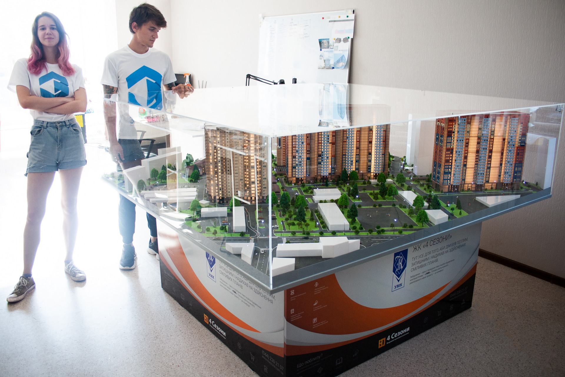
2.1 Physical Models: Materials and Techniques
Physical models are tangible representations of urban environments, often constructed at a reduced scale. These models utilize materials such as foam board, plastic, metal, or 3D printing materials to create an accurate depiction of the built environment.
Techniques may include:
- Scale Modeling: Creating detailed scale replicas of buildings, parks, and transportation networks that highlight spatial relationships within the city.
- Topographical Models: Representing landforms, elevation, and environmental features to comprehend the area’s natural geography and how it affects urban design.
- Interactive Models: Utilizing light, sound, and moving parts to demonstrate change over time, such as traffic flow and population movement.
2.2 Theoretical Models: Frameworks and Approaches
Theoretical models provide frameworks for understanding urban development principles and patterns. They encompass various approaches to city planning, including:
- Land Use Planning: Focusing on the allocation of spaces for residential, commercial, industrial, and recreational uses based on the growth patterns and community needs.
- Behavioral Models: Analyzing how individuals and groups interact within urban spaces, examining elements that influence their decision-making and movement.
- Cultural Theories: Understanding the historical and cultural context of a city and how these factors shape the urban environment and community identity.
2.3 Digital Models: Software and Tools for Urban Planning
Digital models leverage technology to create simulations and visualizations of urban settings. These tools are essential for dynamic planning, allowing urban planners to model complex scenarios and analyze different planning outcomes. Common software and tools include:
- GIS (Geographic Information Systems): Enables the analysis and visualization of spatial data, helping planners make informed decisions based on geographical contexts.
- 3D Modeling Software: Tools like SketchUp and CityEngine allow for the creation of detailed three-dimensional representations of urban environments, facilitating design discussions and public engagement.
- Simulation Programs: Software that can simulate urban dynamics, such as traffic flow and environmental impact analyses, providing critical insights during the planning phases.
3. Key Concepts in City Planning
Effective city planning models are grounded in a few key concepts that frame urban decision-making processes. Understanding these concepts can empower planners to create cities that are more livable, functional, and sustainable.
3.1 Zoning and Land Use Planning
Zoning laws dictate how land can be used and developed, forming the legal foundations of city planning. Effective zoning can reduce conflicts over land use by designating areas for specific purposes such as residential, commercial, or industrial activity.
Land use planning complements zoning by assessing how different land uses interact and how they can be allocated efficiently to optimize space and reduce negative impacts. Planners use both zoning and land use to address needs like housing, transportation, and utilities while promoting a balanced approach to urban development.
3.2 Sustainable Development in City Planning Models
Sustainable development has emerged as a core principle guiding city planning in recent years. It entrains a commitment to creating urban spaces that meet the needs of current and future generations without depleting natural resources or harming ecosystems. Key components include:
- Energy Efficiency: Integrating renewable energy solutions and efficient building designs to minimize environmental footprints.
- Green Spaces: Ensuring the availability of parks and green areas that enhance urban biodiversity and community well-being.
- Transportation Planning: Promoting public transit, biking, and walking paths that support an urban layout conducive to sustainable mobility.
3.3 Community Involvement and Public Participation
Active community involvement in the urban planning process fosters transparency and builds trust between planners and residents. Engaging the public through workshops, surveys, and town hall meetings allows stakeholders to express their needs and preferences, ensuring that the planning models reflect the community’s aspirations. Successful planning processes often incorporate feedback loops where ongoing community input can refine and evolve planning goals over time.
4. Best Practices for Developing City Planning Models
Creating effective city planning models requires a systematic approach that encompasses thorough analysis, community engagement, and the integration of technological advancements. Below are some best practices that can guide urban planners.
4.1 Analyzing Urban Needs and Challenges
An essential step in developing city planning models is conducting comprehensive needs assessments that identify urban issues such as traffic congestion, housing shortages, or social inequities. Planners should:
- Gather quantitative data through surveys and community demographics.
- Conduct qualitative interviews with key stakeholders and community leaders to gain insights on specific challenges.
- Evaluate existing urban infrastructure to identify areas for improvement or investment.
4.2 Integrating Technology in Urban Design
Utilizing technology and digital tools significantly enhances the urban planning process. By leveraging data analytics, simulation software, and geographic information systems (GIS), planners can:
- Create more accurate models that reflect real-world dynamics.
- Visualize complex scenarios that help stakeholders understand planning outcomes.
- Facilitate adaptive management techniques that can adjust plans based on new data and trends.
4.3 Evaluating the Impact and Efficiency of Planning Models
Evaluation is a critical component of urban planning that assesses whether the implemented models achieve the desired outcomes. Following the execution of a city planning model, planners should:
- Establish performance metrics such as transportation accessibility, quality of life indices, and environmental impact scores.
- Conduct regular reviews that can uncover areas needing adjustment or improvement.
- Incorporate feedback mechanisms that allow for continuous engagement with stakeholders and the community.
5. Case Studies: Successful City Planning Models around the World
Examining successful city planning models from around the globe helps urban planners identify effective strategies that can be adapted to various local contexts. This section explores notable case studies and lessons learned from different cities.
5.1 Lessons from Smart Cities
Smart cities utilize technology and data-driven solutions to enhance urban living. Cities like Barcelona and Singapore have implemented intelligent transport systems, integrated public services, and data analytics to manage city functions efficiently. Key lessons include:
- Emphasizing data transparency to foster public trust and engagement.
- Integrating different technological tools to create cohesive service models.
- Encouraging collaborative partnerships among public, private, and academic sectors to enhance innovation.
5.2 Comparative Analysis of Global Planning Models
By analyzing the diverse city planning models across the world, urban planners can gain valuable insights into various approaches and methodologies. For example:
- Sweden’s transit-oriented development emphasizes public transport in its urban design, fostering high-density mixed-use neighborhoods.
- New York City focuses on inclusive zoning, promoting affordable housing and community facilities in highly populated urban areas.
- Tokyo’s innovative use of space addresses urban challenges through vertical development, maximizing limited land.
5.3 Future Trends in City Planning
As urban environments continue to evolve, several future trends are emerging in city planning. Anticipated advancements include:
- Resilience Planning: Cities will increasingly focus on resilience against climate change, natural disasters, and social disruptions by integrating adaptive design features.
- Blockchain Technology: Exploring blockchain could enhance transparency and efficiency in urban governance and land transactions.
- Augmented Reality (AR) Mapping: AR could help visualize future urban developments, allowing the community to engage more dynamically in planning processes.


Post Comment